


![]()
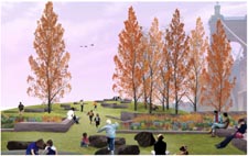
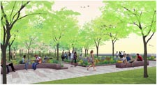
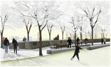
“Our aim is to make Smale Riverfront Park an enduring landscape—a significant space that will last for generations.”
—Sasaki Associates
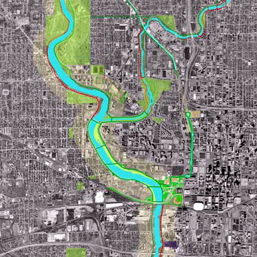
Sasaki Associates—which has created some of the most recognizable icons of modern landscape architecture—was selected as the design firm for Smale Riverfront Park in 2001. Sasaki Associates’ work was inspired by the input of citizen stake-holders at a series of public meetings and focus groups that began in 1998. The design plans are consistent with the area’s Master Plan—approved in 1999 by the City, County, Planning Commission, Park Board and the Urban Design Review —created by Hargreaves Associates.
Here’s a look at the design team behind the creation of Smale Riverfront Park.
Talking with Smale Riverfront Park’s Design Principals
Mark O. Dawson, ASLA / Principal / Landscape Architect

Alistair McIntosh, ASLA, RIBA / Principal / Landscape Architect / Architect

Varoujan Hagopian, PE, FASCE, CSI / Principal / Civil-Waterfront Engineer

Experience
Sasaki’s landscape architecture practice is integrated with civil engineering and urban design to create new designs on diverse and challenging sites, including urban waterfronts—like Smale Riverfront Park.
Sasaki’s extensive portfolio includes many outstanding waterfront projects.
Charleston Waterfront Park
1983-1992
Charleston, South Carolina
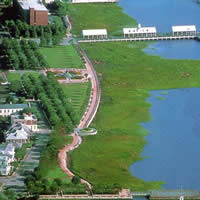
The master plan for the Charleston Peninsula provided the framework for public and private development with the goal of bringing new life to the waterfront and providing a safe, attractive environment that would invite residents, visitors, shoppers, and business people to the historic downtown. Sasaki's subsequent design for the seven-acre Waterfront Park transformed the underutilized Cooper riverfront into a long curving expanse of green that includes a 1,200 foot promenade along the water's edge, recreational piers, shade structures, participatory fountains, lawns and seating walls, and quiet gardens under a grove of live oaks.
Central Indianapolis Waterfront Master Plan
1990-2004
Indianapolis, Indiana
This plan envisions new open space links between the downtown and the river. These new public spaces create the opportunities for adjacent civic, institutional, sports and residential developments on individual riverfront and canal sites.
Central Indianapolis Waterfront Capital City Landing
The first implemented phase of the Indianapolis Waterfront Master Plan is Capital City Landing, the principal park link between the downtown civic and commercial core and the river. The principal organizing elements are the extension of the Central Canal through the park and the National Road Promenade that follows the alignment of the first road from the downtown to the White River. The centerpiece of the park is Celebration Plaza. This green room is oriented to the river via a grass and stone amphitheatre that breaks through the existing floodwall. This new landscape supports developments on sites adjacent to and in the park such as an Imax theatre, the State of Indiana Museum, the NCAA Headquarters, a minor league baseball park and additions to the Indianapolis Zoo.
Central Indianapolis Waterfront The Upper Canal
Sasaki extended the Central Canal northward by three city blocks and created a northern landscape
terminus to this pedestrian recreation corridor. A fountain that incorporates historic canal control gates falls into the canal basin and dominates this water landscape. Tree shaded, sloping banks and a grass and stone amphitheatre surround the basin. Tree lined pedestrian walks line the canal on both banks and create a landscape setting for the adjacent residential, commercial and institutional development that is being built on both banks and around the edges of the north basin landscape.
New London Waterfront Park
1997-2002
New London, Connecticut
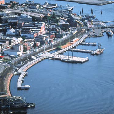
The park is piece of open space infrastructure. It renews the relationship between the commerce of downtown and the transit and recreation activities of the riverfront, thus supporting the urban revitalization goals of the city.
Sasaki provided planning, landscape architecture, civil engineering, and architectural services for the project. Initial planning studies were undertaken in 1997 and construction has been completed in phases between 1998 and 2002.
Boston Waterfront Park & Long Wharf
Boston, Massachusetts
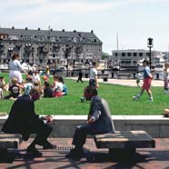
Sasaki’s program for the park recognizes both regional and national visitation and the local recreational needs of the North End and waterfront communities. The design accommodates the passive recreational needs of adults and children in a series of small pedestrian-scale spaces. The major focal point of the design is a plaza surrounded by terraced lawn areas oriented to the harbor. The park is designed to accommodate spontaneous festival and vendor-related activities.
Sasaki Associates provided complete landscape architectural and civil engineering services, working with the City's Redevelopment Authority and Department of Parks and Recreation and with community groups from the formulation of initial concepts to preparation of contract documents and construction administration.
Sasaki also provided landscape architectural, urban design, civil engineering, and environmental permitting services for the restoration of historic Long Wharf, which returns the most dramatic portion of the severely deteriorated wharf to public use. The central upper wharf is an open promenade, highlighted by a large compass rose that provides navigational information. Details enhance the historic importance of the wharf and create a “wharfscape” with materials able to withstand the battering of the sea.